

The Kathmandu Post :
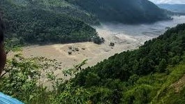
Nepal has yet to determine what triggered the devastating Bhotekoshi flash flood, but officials suspect an earthquake in Tibet may have caused a glacial outburst. This is one of Nepal’s worst disasters since the 2015 earthquakes.
Foreign Minister Shisir Khanal told Parliament on Wednesday that the earthquake struck at 8:37 am, and the flash flood was reported three minutes later, at 8:40 am. “We, however, need to verify this,” he said.
According to the US Geological Survey, a magnitude 4.4 earthquake struck Tibetan territory at 8:37 am, about 47 kilometres north of Gosainkunda.
The National Disaster Risk Reduction and Management Authority said a preliminary study, based on an analysis of Planet Labs satellite imagery, indicates that a debris-laden flood entered the Lhende river after a glacial-rock slide occurred along the Nepal-China border, about 20 kilometres northeast of the Rasuwagadhi border point. The flood then flowed through Timure and entered the Trishuli river.
Authorities in both Nepal and China, however, were unable to determine what exactly caused the massive flood that ravaged several villages, destroyed critical infrastructure and killed several people along the Nepal-China border. The disaster is the second of its kind to hit the region within a year.https://www.facebook.com/plugins/video.php?height=223&href=https%3A%2F%2Fwww.facebook.com%2Freel%2F1054501130621107%2F&show_text=false&width=560&t=0
Khanal said Nepal was seeking real-time data and information from Chinese authorities as well as Nepali research institutions to establish how the massive flood was triggered.
“Since there is no one at the Nepal-China border point and no information is available from the scientific community due to bad weather, we are seeking real-time information from different research centres as well as from the Chinese authorities,” Khanal told the Post.
Laxmi Prasad Niraula, Nepal’s consul general in Lhasa, said some patchy information was emerging about the cause of the flood, but the Chinese side was also struggling to establish what triggered the disaster.
“The Chinese are also clueless about the reason behind the outburst,” Niraula said.
He said the floods had completely disrupted communications, road networks and internet services in the affected areas.
“The root cause is yet to be known. The scientific community is struggling to narrow down the reason behind the floods,” he said.
Niraula said neither Nepali nor Chinese authorities had been able to establish contact with security personnel deployed along parts of the Nepal-China border. As a result, there was no authoritative information on what had triggered the massive outburst.
“We are unable to contact the Nepali side, and the Chinese also have no authentic information about what triggered the massive outburst,” Niraula said. “We suspect it may have been a glacial outburst, but that has not yet been confirmed.”
Tibetan authorities are using satellite imagery and information from local contacts to determine the cause of the disaster.
Niraula said there had been heavy rainfall in the Manasarovar and Ali areas on Tuesday and that could have triggered the massive floods and outburst. “The Chinese side is currently investigating this possibility,” he said.
“They haven’t yet been able to determine not only the cause of the flood, but also where and from what point it originated,” he said, adding that no information had been received from the affected areas because communications remain cut off.
According to Niraula, Chinese officials have also been unable to establish contact with their security personnel stationed along the border, leaving them without reliable information about the scale and cause of the disaster.
Khanal said scientists in Beijing were also trying to determine the exact reasons behind the flash floods.
The disaster has revived concerns over Nepal’s vulnerability to glacial lake outburst floods and the lack of a formal cross-border mechanism for sharing real-time information.
In July last year, a lake formed on top of a glacier in China’s high mountains and burst 35 kilometres upstream from the Rasuwagadhi border point. The surge rushed down the Lhende Khola and Bhotekoshi, crossed the border and affected communities and infrastructure over 80 to 100 kilometres downstream. At least 11 people were killed, including local residents and project workers.
The Miteri Bridge (Friendship Bridge) at Rasuwagadhi was completely washed away.
Following that incident, the two countries agreed to share cross-border real-time information on floods and landslides and flag potential risks of glacial lake outburst floods.
But no formal agreement has been signed to implement such a mechanism.
The issue was again raised during Khanal’s visit to China in May, but the two sides have yet to sign an agreement. The delay has prompted concern among stakeholders over the absence of a functioning early-warning mechanism in a disaster-prone border region.
Following Wednesday’s floods in Rasuwa, the government issued multiple warnings to people living along the Bhotekoshi, Trishuli and Narayani rivers, urging them to move to safer locations in case of further flooding.


 Users Today :
  Users Yesterday :
  This Month :
  This Year :
  Total Users : 1381141
 Views Today :
  Total views : 5000
 Who's Online :